
Berkeley Hills
Berkeley’s most extraordinary addresses — and the most important things to know before you buy one.
The Berkeley Hills Neighborhood
The Berkeley Hills rise sharply from the flatlands east of Spruce Street, climbing through a network of winding canyon streets and forested ridgelines to Grizzly Peak Boulevard at elevations approaching 1,200 feet. As defined here, the neighborhood runs north of Cedar Street and La Loma Avenue — distinguishing it from the Claremont neighborhood to the south — and extends west to Grizzly Peak Boulevard along the ridge. It is bounded to the west by the edge of the flatlands where the streets begin to pitch and the grid begins to dissolve into the canyon topography that defines the hills experience.
This is not a neighborhood you stumble into. The streets wind, the grades are steep, and the relationship between a home and its setting — the view corridor, the canyon, the morning light — is inseparable from the value of the property itself. The hills have been attracting buyers who understand this since the late nineteenth century, when Bernard Maybeck began designing Brown Shingle homes on hillside lots that were integrated into the landscape rather than imposed upon it. His influence, and that of the broader Arts and Crafts movement he represented, is visible throughout the Berkeley Hills in the unpainted redwood-clad homes that define its residential character — those, and the mid-century modern homes that came later, equally attentive to site and view.
The neighborhood’s architectural range is wider than any other in Berkeley. At the lower elevations near Spruce and Euclid, the older Brown Shingles and period revival homes that survived the 1923 fire give way to the canyons and ridgelines above, where mid-century moderns — many designed with floor-to-ceiling glass and flat or shed roofs oriented toward the Bay — represent the purest expression of California indoor-outdoor living. Harwell Hamilton Harris’s Weston Havens House (1940), a California Historic Landmark with an inverted gable roof cantilevered over a hillside site overlooking the Bay, is the most celebrated example. William Wurster’s Greenwood Common, a planned enclave of eight modernist homes around a shared green space, represents the neighborhood’s mid-century collective vision. Contemporary and architect-designed infill homes continue to be built here, many achieving EMBER compliance from day one — a meaningful advantage in the current market.
Megan’s take
“The Berkeley Hills attract buyers who have thought carefully about what they want from a home. They’re not trading walkability for views on accident — they’re making a deliberate choice for a different way of living, one that’s closer to the park, closer to the ridge, and further from the noise. What I tell every hills buyer is the same thing: understand the fire risk and insurance picture before you fall in love with a property, not after. The buyers who go in prepared — with a structural engineer lined up and realistic insurance costs modeled into their budget — end up owning some of the most extraordinary homes in the Bay Area. The ones who don’t prepare are the ones who are surprised. And surprise is expensive in a hills transaction.”
What is daily life like in the Berkeley Hills
Daily life in the Berkeley Hills is organized differently from every other Berkeley neighborhood. There is no commercial corridor within easy reach, no farmers market two blocks away, no neighborhood cafe at the end of the street. What there is instead is direct access to one of the finest regional parks in the United States, morning views of San Francisco Bay and the Golden Gate, and a quality of quiet that is genuinely rare at this price point and this proximity to a major city.
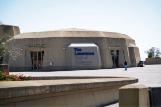
Most hills residents do their shopping in the flatlands below — on Solano Avenue, in Elmwood, or along North Shattuck — and treat the drive down as a routine part of hills life rather than a hardship. The Lawrence Hall of Science, perched on the hillside above the UC Berkeley campus with panoramic Bay views and hands-on science programming for children, is one of the neighborhood’s anchor institutions and a consistent draw for families. The network of public pedestrian stairways and paths that thread through the Berkeley Hills — maintained by the city as public rights-of-way — provides a form of connectivity that maps don’t capture: neighbors know which paths link which streets, and that knowledge becomes part of daily life in ways that feel genuinely community-building.
The microclimate is part of the daily experience. The east and south slopes of the Berkeley Hills often sit in a fog shadow, receiving more direct sun than the flatlands below on summer afternoons when the Bay is socked in. The trade-off comes from the Diablo winds — the hot, dry northeasterly winds that blow from the interior in late summer and fall, which push temperatures upward and fire risk higher simultaneously. Most hills residents understand this seasonal rhythm and plan around it.
Fire Risk and Insurance: What Homeowners Need to Know
The Berkeley Hills sit within the Very High Fire Hazard Severity Zone (VHFHSZ) designated by CalFire, and most of the neighborhood falls within Berkeley’s Hillside Overlay District. This is not a technical footnote — it has direct, material implications for ownership costs and transaction complexity that every buyer needs to understand before making an offer.
The fire history here is real. The catastrophic 1923 fire destroyed approximately 640 structures in the North Berkeley hills under Diablo wind conditions. The 1991 Tunnel Fire — the same weather pattern, the same ridge, 68 years later — killed 25 people and destroyed more than 3,000 homes across the Oakland-Berkeley hills. The vegetation has grown denser since 1991, and non-native eucalyptus trees introduced in the early twentieth century add high-fuel-load conditions to already fire-prone slopes. The seasonal Diablo winds that drove both fires recur every year. UC Berkeley, the East Bay Regional Park District, and the Berkeley Fire Department all operate ongoing fuel management programs, and a network of AlertCalifornia cameras provides early detection across the ridge — but the underlying conditions are structural, not cyclical.
For buyers, the practical implications are three. First, insurance. The admitted carrier market in California’s high-fire-hazard areas has contracted significantly, and many hills properties now require non-admitted carrier coverage or the California FAIR Plan as a backstop. Buyers should budget for homeowner’s insurance running materially above flatlands rates — the FAIR Plan announced a 30% premium increase for 2026 — and should model that cost into their purchase economics from year one, not as an afterthought. Second, EMBER Zone 0 compliance applies to properties east of Grizzly Peak Boulevard and requires ongoing vegetation management and defensible space maintenance. Third, seismic reinforcement: the hills sit above the Hayward Fault, and unreinforced foundations are common in pre-1950 homes. A qualified structural engineer can assess and scope the work required, typically at approximately $1,000 per linear foot — a bounded and manageable cost when approached proactively.
None of this should be read as a reason not to buy in the Berkeley Hills. The buyers who navigate these requirements successfully — and thousands do, every year — end up owning homes that cannot be replicated anywhere in the Bay Area. The key is preparation: go in with open eyes, model the real carrying costs, and work with professionals who know this specific terrain. That is the difference between a hills transaction that closes confidently and one that unravels at the disclosure stage.
What schools serve the Berkeley Hills?
Parks and outdoor life in the Berkeley Hills
Tilden Regional Park is the Berkeley Hills’ defining outdoor asset and one of the primary reasons buyers choose this neighborhood over any other in Berkeley. The park’s 2,079 acres sit directly above the neighborhood, accessible from multiple canyon entrances and from Grizzly Peak Boulevard along the ridge. From many Berkeley Hills addresses, the park boundary is within a few minutes on foot — a trail connection that is not hypothetical but genuinely daily for residents who use it that way.
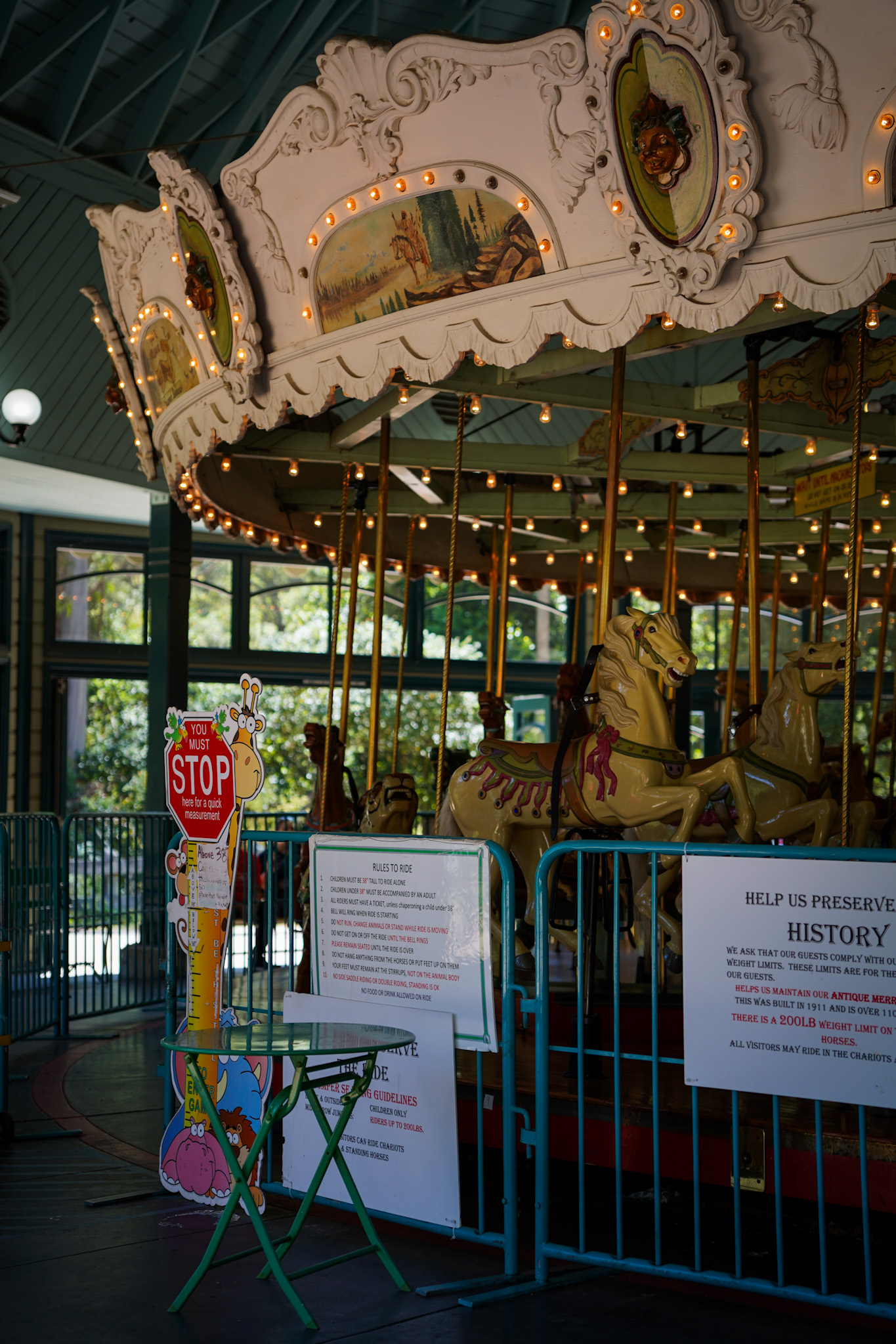
What Tilden offers within those 2,079 acres is unusual for a regional park: hiking, cycling, and equestrian trails totaling more than 39 miles; the Tilden Nature Area with Jewel Lake and Wildcat Peak at 1,211 feet; Lake Anza for summer swimming; Inspiration Point with panoramic views of the Bay, San Francisco, the Golden Gate, and Mount Tamalpais; a working Little Farm where children can feed livestock for free; the Redwood Valley Railway steam train; the 1911 hand-carved Herschell-Spillman carousel listed on the National Register of Historic Places; and a golf course and the Brazilian Room event venue. It is not one thing — it is everything a regional park can be, within walking distance of a residential neighborhood.
Wildcat Canyon Regional Park, immediately north of Tilden along the ridge, extends the accessible open space further — 2,789 acres of grassland, oak woodland, and creek canyon connecting to trails that reach into Contra Costa County. The combined Tilden-Wildcat system represents a wilderness buffer immediately adjacent to the neighborhood that is protected in perpetuity by the East Bay Regional Park District.
Berkeley’s network of public pedestrian stairways and paths provides a secondary outdoor infrastructure throughout the hills. These maintained rights-of-way — some concrete, some wooden, some landscaped — link streets that the road network does not connect, creating a pedestrian grid that rewards local knowledge and makes the neighborhood more navigable on foot than it first appears.
Getting around from the Berkeley Hills

Berkeley Hills neighborhood map

Thinking about the Berkeley Hills?
I’ve represented buyers and sellers throughout this neighborhood for years. If you’d like a candid conversation about what’s available and what to expect, I’m always glad to talk.
Frequently asked questions about the Berkeley Hills
Berkeley Hills Resources
Berkeley Hills resources
Links open in a new window. If you find a broken link, let us know.